The Field Edge as a Record of the Land
The field edge records the land in visible layers; learn what hedges, slopes and water can suggest, and how to observe them without mistaking clues for proof.
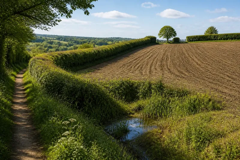
At the corner of a field, a hedge bends around a wet hollow while the ploughed ground above it runs straight towards a gate. The field edge records the land in visible layers: boundaries, slopes, vegetation and water all meet there. Watching those features over a week can reveal how a place is organised, without turning a suggestive shape into a confident story about its past.
A week at the edge
Choose one field boundary that can be viewed safely from a public path or another permitted place. The aim is not to walk its full length, trespass for a better view or identify who owns it. Pick a section where at least two features meet: perhaps a hedge and a ditch, or a bank and a gate.
Use the same viewpoint on several visits across a week. A morning and an afternoon may look different as light shifts; a visit after rain can make water movement easier to notice. If conditions do not change, the routine still works. The task is to compare observations, not to wait for dramatic weather.
- First visit: note the broad arrangement of field, boundary and nearby ground.
- Second visit: follow the boundary visually and record where it bends, narrows or meets another feature.
- After rain, if convenient: look for damp patches, puddling or water entering a ditch.
- Later in the week: compare the same view and separate persistent features from temporary ones.
- On the final visit: write down what remains uncertain as well as what is clear.
A small notebook is enough. A simple sketch can show which side of the boundary slopes down, where a gate interrupts the hedge, and whether water seems to collect nearby. Avoid recording private details about residents or farms. The useful record is of the visible landscape, not a directory of its users.
Read the boundary
A boundary is both a line and a meeting place. A hedge may shelter a field, mark a division or follow a change in the ground. A ditch may carry water, define an edge, or do both. Their form can suggest practical choices, but the same appearance can have more than one explanation.
Look for continuity before interpreting purpose. Does the hedge continue across the slope, turn sharply, or stop at a gate? Does a ditch follow it, cross beneath it or appear only in the low part? A boundary that follows uneven ground may be responding to the terrain; a straight run may reflect a deliberate division. Neither observation, by itself, establishes when or why it was made.
Vegetation gives another layer of evidence. A dense hedge, a thin line of shrubs and an open bank each affect what can be seen across the field. Notice whether the plants vary along the edge and whether gaps coincide with gates, tracks or wet ground. Do not assume that a change in planting marks an old boundary: maintenance, access and local conditions can also shape what grows there.
Keep the description plain: “the hedge curves into the hollow” is more useful than “the hedge follows an ancient route” unless there is independent evidence for that claim.
Follow slope and water
The ground beneath a field edge often makes its pattern easier to read. A bank may rise on one side, flatten on the other, or fade where the land becomes wet. Look across the slope as well as along the boundary. A low point can explain why water gathers there, while a higher strip may stay relatively dry after rain.
Water is especially useful to observe because its presence changes with conditions. A ditch may be dry on one visit and flowing on another. A puddle can form after a shower without marking a permanent wetland; a strip of damp vegetation may persist when the surface looks dry. Record the conditions and what you can actually see, rather than treating one visit as a complete account.
Say you notice a hedge that bends around a shallow dip, with a narrow ditch beside it. After rain, water stands briefly in the dip, but the next visit shows no visible flow. A careful note would record the curve, the ditch and the temporary standing water. It would not claim that the hedge was placed to control drainage, since the visible arrangement alone cannot establish that purpose.
Where the land is difficult to read, compare the edge with nearby features visible from the same public place. A road, stream or woodland margin may help clarify which way the ground falls. Keep the comparison modest: neighbouring features can suggest a broader pattern without explaining every boundary.
What can a field edge tell you?
Does a straight boundary mean the land was reorganised?
It may suggest a planned division, but straightness is not a date or a history. Check whether the line follows a slope, track or other visible feature, and leave its origin open if the evidence does not settle it.
Can a hedge show where water flows?
It can sit beside a ditch or a damp run, but the relationship needs observation in different conditions. Look for visible direction, repeated pooling or a clear channel; a single wet patch is not enough to trace a route.
What should I record on a field-edge visit?
Note the boundary’s shape, its interruptions, the ground’s slope and any visible water, along with the weather or recent rain. A sketch and short factual descriptions make later comparisons easier than a list of guesses.
Can I inspect a boundary from the field itself?
Only if access is permitted. A public footpath or roadside viewpoint is often enough to observe the pattern, and entering a field for a closer look is not necessary.
Keep the record modest
At the end of the week, arrange notes under three headings: seen, repeated and uncertain. “A ditch runs beside the lower hedge” belongs under seen. “Water collected in the same hollow after two visits” may belong under repeated. “The boundary was made to drain the field” remains uncertain unless another source supports it.
This separation matters because field edges invite tidy explanations. A hedge seems to belong with a bank; a bend seems to point to an old route; a wet hollow seems to explain the whole arrangement. Sometimes those links are right. The landscape itself, however, offers clues in fragments, and each feature can reflect more than one choice or condition.
Photographs can help if taken from a lawful viewpoint and framed around the landscape rather than identifiable people or private spaces. Keep the viewpoint consistent where possible, and note the direction you faced. Images do not replace written observations: a picture may show a hedge clearly while leaving its relation to the slope hard to judge.
Notice change without claiming too much
A week will not uncover a complete history. It can show what changes with light or rain, what stays in place, and how boundaries relate to the ground around them. That is already a useful way to understand a landscape: not as a puzzle with one hidden answer, but as an arrangement whose visible parts can be described carefully.
If the field edge continues to interest you, return in another season and repeat the same modest routine. Compare the shape of the boundary and the ground, while allowing for changes in vegetation and water. The field edge records the land most clearly when the observer keeps the record precise and the explanation provisional.